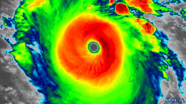
But now Beryl is finally dissipating. The storm has turned into a “subtropical depression,” or the remnants of a mid-latitude low-pressure system, and is moving through Canada. In its wake, more than a million customers in the Houston area are still without power, and people in the Mississippi and Ohio valleys and Northeast are still cleaning up from tornadoes and flooding caused by Beryl’s remains.
The storm caused the most damage in Grenada, where Beryl struck the island on July 1 as a Category 4 storm, quickly strengthening to a Category 5 storm.
Here we look back on Beryl’s voyage and highlight key moments from her historic voyage across the Atlantic, the Caribbean and the United States.
16 days ago: The National Hurricane Center’s initial forecast identified an area of disturbing weather over the eastern tropical Atlantic that had emerged off the coast of Africa the previous day, June 24. This was the tropical wave that would become Beryl.
13 days agoOn June 28, the tropical wave became a tropical depression and the precursor to a named storm. Initial warnings indicated that the storm could eventually become a hurricane as it struck the Lesser Antilles. The system was named Beryl at 11:00 PM Atlantic time.
12 days ago: Just 24 hours after being declared a tropical storm, Beryl became a Category 1 hurricane 720 miles east-southeast of Barbados with winds of 75 mph. A hurricane warning was issued for Barbados, and hurricane watches were issued for St. Lucia, St. Vincent and the Grenadines, and Grenada (Grenada was where Beryl eventually hit first).
11 days ago: At 5:00 PM Atlantic time on June 30, Beryl was declared an “extremely dangerous Category 4 hurricane”. Maximum sustained winds were recorded at 130 miles per hour. This made Beryl the southernmost Category 4 hurricane ever recorded in the Atlantic, the fastest-forming Category 4 hurricane on record, and the fastest-intensifying hurricane on record prior to September.
10 days ago: On the morning of July 1, Beryl struck the Grenadian island of Carriacou, engulfing the island in an eyewall, or ring of destructive winds, with winds of 140 mph. Extensive damage was reported. By 11:00 pm Atlantic time, Beryl had become the fastest Category 5 hurricane on record. It strengthened overnight with sustained winds of 160 mph.
9 days ago: On July 2, estimated maximum sustained winds at the center of Beryl reached 165 mph, eight mph above the Category 5 threshold, making it the strongest July storm ever recorded in the Atlantic.
8 days ago: On July 3, Beryl struck southern Jamaica as a Category 4 storm, with its center scraping off the southern tip of the island.
7 days ago: On July 4, the northern part of Beryl struck the Cayman Islands as a Category 3 storm. Its intense eyewall winds remained south of the islands, and the Cayman Islands were primarily affected by tropical storm forces.
6 days ago: Beryl struck Mexico’s Yucatan Peninsula on July 5, coming ashore as a Category 2 storm with sustained winds of 110 mph, but weakened quickly after making landfall near Tulum.
5 days ago: On July 6, Beryl emerged as a tropical storm in the southwestern Gulf of Mexico, weakened and lost much of its central core, and spent much of the next day trying to regain strength.
4 days ago: By 11:00 pm CST on July 7, Beryl had returned to hurricane status.
3 days ago: Beryl made landfall at 4 a.m. CST on Monday in Matagorda, Texas, as a Category 1 hurricane. Its sudden eastward course put Houston in the eastern eyewall, the fiercest part of the storm, which lashed the metropolitan area with 80 mph winds and dumped up to a foot of rain. About 2.5 million customers lost power. Tornadoes then touched down in northeast Texas, southern Arkansas, and western Louisiana in the afternoon. The National Weather Service issued 115 tornado warnings, a July record.
2 days ago: On June 9, Beryl weakened to a tropical storm as it moved along the Indiana-Ohio border, leaving behind several tornadoes, including a devastating one in Mount Vernon, Indiana, that destroyed a warehouse.
1 day ago: As Beryl’s remnants moved along the borders of eastern Canada and the northeastern United States, its residual rotation produced rotating thunderstorms and multiple tornadoes in New York and neighboring states. In New York, the National Weather Service issued a state-record 42 tornado warnings in a single day, with over 200 total tornado warnings issued as Beryl moved across the Lower 48 states over three days. Meanwhile, extensive flooding hit northern Vermont, with rainfall totals of 4 to 6 inches.
Thursday: Beryl dissipated into a subtropical depression northeast of Lake Ontario in southern Canada.


